Honey Hollow Watershed
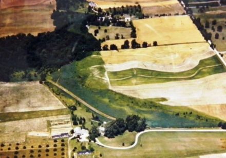
The Honey Hollow Watershed is located approximately 30 miles northeast of Philadelphia. The 650-acre landscape is dominated by farmhouses and fieldstone fences dating back to the original 1682 land grants of William Penn. The story of the hollow, and the farmers who called it home, act as a national model for watershed preservation through cooperation.
For more than 200 years, farmers in the hollow used the land to grow crops for their families and friends. However, by the mid-20th century, the land was showing its age. Erosion and soil depletion from the many years of farming were taking a toll. In the spring of 1939, the farmers reached out to the regional office of the U.S. Soil Conservation Service. The regional director, Dr. John Paul Jones, realized the erosion issues were a watershed-wide problem. He told the farmers he would provide assistance, if they worked together. And work together they did; some of the techniques they put in place then are still in use today.
Dr. Hugh Bennett of the Soil Conservation Service once wrote about the project, “This is nearly a unique thing, but my prediction is it will not be unique for long. After all, this country of ours is made up of a lot of watersheds, and what can be done in one watershed can be done on other watersheds and will be done.”
In 1969, the Honey Hollow Watershed was designated as a National Historic Landmark. That same year, the Honey Hollow Watershed Association was formed by interested neighbors. In 1980, they worked with the Bucks County Audubon Society to build the Honey Hollow Environmental Education Center, on land donated by the Crooks family. Together, these partners continue to expand the educational offerings and share the story of cooperation and conservation. You can learn more about the hollow and its history here.
Photograph used with permission of Bucks County Audubon Society.